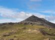
The Mount Amiata Volcano Trail (cammino del Vulcano Amiata) is a scenic circular route of about 120 kilometers located in the heart of southern Tuscany, around Mount Amiata. This hiking itinerary, considered challenging, winds around an ancient volcano, crossing medieval villages, dense forests and breathtaking landscapes between the Val d’Orcia and the Maremma.
Each village along the trail can serve as a starting point: Abbadia San Salvatore, Santa Fiora, Arcidosso, Castel del Piano and Seggiano.
The route divides the journey into five main stages, each with detailed technical information including distances, walking times and elevation changes.
In addition to technical information, the trail’s website also offers practical advice on accommodation and equipment, allowing hikers to customize their starting point and plan their journey.
The initiative aims to enhance the identity of the territory, promoting a form of slow tourism that combines nature, history and spirituality.
Important:
Trail signage is currently being completed and the route will be ready by early summer 2026. Stay tuned to this page for updated information.
For more information:
www.ilcamminodelvulcanoamiata.it